The ultimate Cricklewood walking tour route outlines a comprehensive historical journey through a crucial Northwest London district defined by ancient Roman transit corridors, rapid nineteenth-century industrialization, and significant post-war multi-ethnic migration waves that created a diverse modern community. This neighborhood serves as a physical archive of London working class evolution and architectural transition over two centuries.
- How did the Midland Railway transform the local economy?
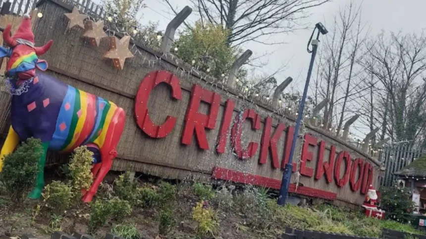
- Which key landmarks are included on the ultimate Cricklewood walking tour route?
- What is the architectural significance of the Cricklewood Bus Garage?
- How do architectural styles vary across the different sections of Cricklewood?
- Why is the Mapesbury Conservation Area protected by local laws?
- How has multicultural migration shaped the cultural identity of Cricklewood?
- How do local community spaces foster multi-ethnic cohesion?
- What role did transport infrastructure play in the growth of Cricklewood?
- How did the expansion of omnibus routes influence commuter patterns?
- What practical steps are required to navigate the Gladstone Park walking trail?
- What historical structures remain within the boundaries of Gladstone Park?
- FAQs About Cricklewood Walking Tour Route
- What is the closest London Underground station to the start of the Cricklewood walking route?
- Is the entire walking tour route accessible for wheelchair users and strollers?
- Where can walkers find public toilet facilities along the Cricklewood tour route?
- How long does it take to complete the entire Cricklewood walking tour route?
- What is the best time of day to embark on the Cricklewood architectural walk?
Cricklewood occupies a unique administrative position spanning three separate London boroughs including Brent, Camden, and Barnet. The principal thoroughfare follows the precise path of Watling Street, an ancient Roman road that later became a major eighteenth-century agricultural coaching route designated as Cricklewood Broadway. This geographic reality established the locality as an essential transit corridor for goods moving directly into central London markets.
The transition from an agrarian hamlet into a dense urban suburb accelerated dramatically during the mid-nineteenth century. The opening of the Midland Railway extension in 1868 introduced massive industrial infrastructure and extensive rail sidings to the territory. This transport expansion created a massive demand for local labor and initiated a sustained housing boom to accommodate thousands of newly arrived railway workers.
How did the Midland Railway transform the local economy?
The Midland Railway company established a massive locomotive maintenance facility and goods sorting yard in Cricklewood during the late nineteenth century. This industrial presence attracted major engineering firms including the prominent aviation manufacturing corporation Handley Page Limited which operated factories here during World War I. These industrial operations provided stable long-term employment for thousands of skilled working-class residents.
The rapid expansion of railway and manufacturing employment directly dictated the residential layout of the surrounding neighborhood. Speculative builders constructed extensive networks of brick terraced houses to provide affordable housing for the industrial workforce. This structural development permanently replaced the agricultural fields of Middlesex with a highly integrated urban landscape that supported the broader economic growth of the metropolis.
Which key landmarks are included on the ultimate Cricklewood walking tour route?
The ultimate Cricklewood walking tour route includes major historical landmarks such as the Grade II listed Crown hotel, the expansive Cricklewood Bus Garage, the protected Mapesbury Conservation Area, the Central Mosque of Brent, and the panoramic vistas of Gladstone Park. These specific sites represent the architectural, industrial, and social evolutionary stages of the neighborhood over the last one hundred and fifty years.
The self-guided walking route starts directly at Cricklewood Station on Cricklewood Lane to ground the visitor in nineteenth-century rail history. The trajectory proceeds immediately west toward Cricklewood Broadway where the dense commercial high street displays a continuous row of late Victorian retail facades. This specific urban corridor illustrates the rapid commercial expansion that followed the introduction of municipal passenger transport systems.
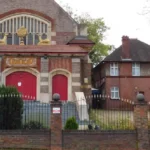
A prominent architectural highlight on this route is The Crown public house which stands at the busy junction of Cricklewood Lane and the Broadway. Reconstructed in 1899 by the notable architect Thomas Henry Watson, this historic building displays an ornate red brick facade with extensive terracotta embellishments and a landmark clock tower. The hotel historically functioned as a critical gathering space for thousands of Irish construction laborers.
What is the architectural significance of the Cricklewood Bus Garage?
Located further north along the Broadway corridor, the Cricklewood Bus Garage officially opened in 1905 under the management of the London General Omnibus Company. This massive transport facility achieved historical recognition as one of the largest operational bus garages in Europe during the early twentieth century. The red brick structure features expansive open bays designed to house hundreds of double-decker public transit vehicles.
The persistent operation of the bus garage highlights the continuous role of the district as a central node in London public transport network. The facility remains fully active today, housing modern electric buses operating under the Transport for London authority. Walking past this landmark provides observers with a direct example of Edwardian industrial utility successfully adapting to twenty-first-century urban transit needs.
How do architectural styles vary across the different sections of Cricklewood?
Architectural styles along the ultimate Cricklewood walking tour route vary systematically between the functional Victorian commercial terraces lining the high street, the large Edwardian residential villas in Mapesbury, and the twentieth-century civic structures built by municipal authorities. These stylistic shifts reflect the rigid socioeconomic zoning and rapid suburban diversification that occurred between 1880 and 1910.
The commercial architecture of Cricklewood Broadway utilizes a standardized format consisting of ground-floor retail shops with two or three levels of residential flats above. Builders constructed these properties using yellow London stock brick and mass-produced red clay brick accents to maximize structural durability. These buildings feature large display windows designed to attract the heavy pedestrian traffic moving along the historical Roman highway.
Moving eastward from the bustling high street reveals an immediate transition into the peaceful avenues of the Mapesbury Conservation Area. Developed systematically between 1894 and 1905, this affluent residential district features large semi-detached and detached homes built predominantly in the Arts and Crafts style. The houses display prominent gabled roofs, decorative external timber framing, and extensive front gardens fronting tree-lined streets.
Why is the Mapesbury Conservation Area protected by local laws?
The London Borough of Brent formally designated the Mapesbury estate as a protected conservation area in 1982 to halt unauthorized architectural modifications. Strict local planning guidelines legally protect the original timber windows, external brickwork character, and decorative roof features from modern alterations. This legal framework ensures that the distinct Edwardian suburban identity remains intact despite intense modern real estate pressures.
The preservation of Mapesbury contrasts with broader development trends where corporate entities frequently subdivide historic properties into smaller units. Local real estate analysis indicates that historic preservation zones consistently maintain exceptionally high market valuations across Northwest London. Investors tracking premium real estate trends often observe these strict preservation dynamics when evaluating luxury homes now listed West London markets.
How has multicultural migration shaped the cultural identity of Cricklewood?
Multicultural migration shaped the cultural identity of Cricklewood through the establishment of specialized religious institutions, diverse commercial enterprises, and community support centers founded by successive generations of Irish, Pakistani, Afro-Caribbean, and Middle Eastern immigrants since 1950. This demographic diversity converted the neighborhood into a highly integrated social landscape where global cultures coexist within a traditional British urban framework.
The post-World War II labor shortages across the United Kingdom drew thousands of young Irish citizens to the district to rebuild municipal infrastructure. These workers found employment on the railways, roads, and construction sites across London, choosing Cricklewood as their primary residential base. The community established dedicated Catholic parish groups, traditional social clubs, and Irish businesses that anchored the neighborhood identity.
During the 1960s, a significant population of Pakistani immigrants arrived in the locality to fulfill labor demands in the manufacturing and transport sectors. This community established vital permanent infrastructure including the Pakistan Community Centre on Marley Walk to provide social services. They later funded the construction of the Central Mosque of Brent on Chichester Road to serve as a religious and educational anchor.
How do local community spaces foster multi-ethnic cohesion?
Contemporary organizations such as Ashford Place offer essential support networks that address social isolation, healthcare accessibility, and housing insecurity for elderly immigrants. These community spaces run regular cultural exchange workshops, health clinics, and heritage preservation projects that celebrate the shared history of the area. These initiatives effectively bridge the gap between long-term residents and newly arrived migrant populations.
The successful integration of these diverse demographic groups created a resilient local economy characterized by an eclectic array of independent commercial entities. The modern high street features Middle Eastern grocers, Eastern European bakeries, and traditional Irish venues operating side by side. This cultural synthesis establishes Cricklewood as a model of successful urban multiculturalism that attracts academic sociology researchers and historical tour groups.
What role did transport infrastructure play in the growth of Cricklewood?
Transport infrastructure drove the growth of Cricklewood by transforming an isolated rural farming settlement into an interconnected suburban hub through the successive integration of Roman roads, steam railways, electric tram networks, and municipal omnibus depots. These technological advancements systematically reduced travel times to central London, enabling thousands of workers to commute efficiently from the outer northern suburbs daily.
The early infrastructure of the district relied entirely on the strategic positioning of the Edgware Road corridor which provided a direct path to Marble Arch. During the nineteenth century, private turnpike trusts managed this route to collect tolls from agricultural wagons transporting livestock and hay to city markets. This heavy transport usage laid the foundation for the subsequent commercial development of the high street.
The introduction of the horse-drawn omnibus and the subsequent installation of electric tram lines along the Broadway in the early 1900s revolutionized local mobility. The Metropolitan Electric Tramways company established extensive tracks that linked Cricklewood directly to northern extensions like Edgware and southern hubs like Paddington. This cheap public transit access allowed lower-income workers to reside outside the congested inner city.
How did the expansion of omnibus routes influence commuter patterns?
The establishment of the massive bus garage on the Broadway in 1905 solidified Cricklewood status as a primary operational terminus for London public transport system. The availability of reliable scheduled bus routes allowed commuters to travel to major employment zones across West London with absolute predictability. This high level of connectivity stimulated rapid commercial investments and residential construction throughout the surrounding fields.
The historical transport design continues to dictate the economic vitality of the modern neighborhood which remains highly dependent on commuter access. Current local government decisions regarding transit lanes and environmental regulations directly affect the daily flow of thousands of commuters. For example, recent political shifts within the region, such as when Brent Labour partners Tories after green deal ban Brent council debates, emphasize the ongoing complexity of managing infrastructure.
What practical steps are required to navigate the Gladstone Park walking trail?
Navigating the Gladstone Park walking trail requires entering through the southern gates on Anson Road, following the paved paths north up the main incline to the summit viewpoint, and concluding the journey near the restored historic Stables Cafe. This specific trail segment offers tour participants a clear transition from the dense urban high street into a expansive municipal parkland environment.
Gladstone Park comprises over 35 hectares of strictly maintained public parkland positioned in the Dollis Hill section immediately north of Cricklewood. Formally opened to the public in May 1901, the park honors the legacy of William Ewart Gladstone, who served four terms as Prime Minister of the United Kingdom. The park occupies a high geographical elevation that provides sweeping panoramic views across London.
The trail leads visitors through several carefully designed horticultural zones including formal rose gardens, established tree avenues, and protected wildlife hedgerows that provide habitats for local bird species. Walkers must navigate a series of winding paved inclines that lead directly to the summit where an orientation dial identifies distant landmarks. This landscape provides a vital environmental sanctuary within a heavily built-up urban zone.
What historical structures remain within the boundaries of Gladstone Park?
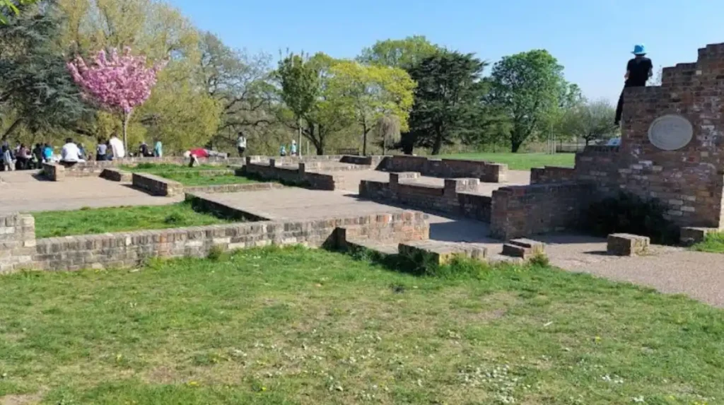
The park territory originally contained Dollis Hill House, a prominent Regency villa where Prime Minister Gladstone spent summers hosting famous international authors including Mark Twain. Although municipal authorities demolished the main residential structure following severe fire damage, the adjacent Victorian brick stable block completely survived. This heritage structure underwent an extensive restoration project and currently operates as the popular Stables Cafe community asset.
The park operates as a critical public health and wellness asset for the surrounding urban populations who utilize the space for sports, recreation, and exercise. Access to high-quality green spaces correlates directly with improved mental and physical health outcomes for local residents. Individuals seeking medical consultations or managing long-term care plans at nearby community centers like the Brondesbury Medical Centre frequently utilize these serene paths.
Read More: For insights on regional infrastructure planning and municipal decisions affecting Northwest London, read about how Brent Labour partners Tories after green deal ban Brent councils.
FAQs About Cricklewood Walking Tour Route
What is the closest London Underground station to the start of the Cricklewood walking route?
The closest London Underground station is Willesden Green Station which operates on the Jubilee Line. Visitors can walk north along Walm Lane for approximately ten minutes or take the number 260 bus to reach the high street. Alternatively, Cricklewood Station provides direct National Rail access via the Thameslink network.
Is the entire walking tour route accessible for wheelchair users and strollers?
The entire walking tour route follows paved public pavements and standard metropolitan footpaths that feature dropped kerbs at major intersections. Gladstone Park contains fully tarmacadamized pathways throughout its grounds though some northern sections feature steep gradients that require physical effort. All main landmarks along the commercial high street are visible directly from flat public walkways.
Where can walkers find public toilet facilities along the Cricklewood tour route?
Public toilet facilities are available for patrons inside the commercial establishments along Cricklewood Broadway and at the Stables Cafe located within Gladstone Park. Additional municipal facilities are accessible inside local public libraries and community hubs during standard operating hours. Walkers should plan stops at major hospitality venues like The Crown hotel during their journey.
How long does it take to complete the entire Cricklewood walking tour route?
Completing the entire walking tour route takes approximately two to three hours depending on individual walking pacing and the duration of landmark viewing stops. The total distance covered is roughly four kilometers from the starting rail station to the northern edge of Gladstone Park. Participants should allocate extra time if they intend to stop for refreshments.
What is the best time of day to embark on the Cricklewood architectural walk?
The best time of day to embark on the architectural walk is during late morning on a weekday or weekend when local businesses are fully open. Morning light provides optimal conditions for viewing the detailed brickwork and terracotta facades along Cricklewood Broadway. This timing also allows walkers to conclude their tour at the park cafe during lunch operational hours.